Walking along the side of Palongcuo Lake seems to be the shortest route, but it turns out that this road is impassable. There is a huge cliff in front of it. It is obviously too dangerous to drive from the frozen lake. If the ice cracks, the consequences will be unbearable. You can only go back. The sand looks solid, but it is easy to get stuck. You can only rush diagonally. The plateau loses a lot of power, and the steeper slopes will slip and lose grip. Later, it was a long way back and forth before returning to the main road.
I wanted to take a shortcut, but actually walked a lot more.


After passing Palongcuo, we encountered difficulties, the bridge was not connected, the upper layer of the river was frozen, and the lower layer was gurgling again. There is no place to go around at all, it seems that the only way to venture across the ice is.
The ice sloped so badly that I didn’t dare to step on the brakes at all, for fear of slipping down the slope. The river crossing route is optimistic and kept in mind, so I chose the narrowest and shallowest place and rushed over. I’m afraid of getting stuck in the car, and I don’t even have an anchor point.
I just passed the first difficulty with trepidation, and I was silently praying that the next step would make it easier for me to walk. Before I drove 200 meters, the second difficulty came. The fault in the middle of the river is at least 40 centimeters. It is also impossible to rush past, and getting stuck is the only ending.
You can only go back the same way for a short distance to find possible river crossing points.
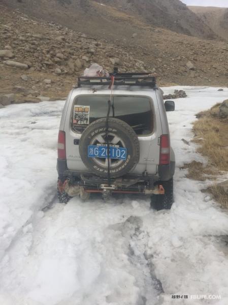
The third difficulty was a half-thawed icy road. The car was locked on the low four rear locks, and it got stuck after a short dash, unable to move forward or backward.
Before rushing, I was also optimistic that there were super large stones on the roadside that could be used as anchor points, and I was optimistic about the route. Otherwise, if you get stuck and cannot save yourself, there is no way out.

After passing through this section of the valley, the road ahead gradually opened up, and the roadbed was gradually formed. After two days of unmanned roads, I came to the village, and I was still inexplicably excited. After all, it is a herd animal. The government’s policy support for remote economically underdeveloped areas is quite good.


Leaving Xiaji Village, the measures I have passed through at this time are already somewhat aesthetically fatigued.


The Tibetan wild donkeys on the side of the road seem not to be afraid of people anymore. They watch your car drive by, grazing on their own, and occasionally look up at you curiously.

Zabuye Chaka is a lithium-rich salt lake, one of the three largest lithium salt lakes in the world. Its lithium content ranks second in the world and first in China, and its cesium content is also in the forefront of the world.
More than 2 million years ago, Zabuye Chaka belonged to an ancient lake basin named Longer. At that time, the lake was distributed in a wide area, and the lake surface was more than 100 meters higher than the modern salt lake. Later, when the climate became dry, the lake began to shrink, and the Longer Basin disintegrated, forming many secondary lake basins from high to low. Zabuye Chaka was located in the lowest sub-lake basin, and the higher lake basins around it were in the form of Arranged in a ring, connected by multiple lake chains and Zabuye Chaka. In the process of surface or underground brine supplying Zabuye Chaka through these lake chains, some salt components are dissolved along the way to enrich the brine. In this way, Zabuye Chaka becomes salt under the supply of high-level saline lakes It has the longest time, the most soluble salt, and the scale is getting bigger and bigger. Up to now, it has formed the largest comprehensive deposit of boron, lithium, potassium and other salts in Tibet.
It’s just that the sky is gloomy, and it doesn’t show the beauty of Zabuye.

After going through hardships and obstacles, I came to Pajiang Township. Although there are low mud houses everywhere, the streets can be seen at a glance. Anyway, it is also a township. There are supermarkets and housing, and it is full of happiness.

There are still lights on the street

There should be no electricity in the village, and the power supply is solar energy
Pajiang Township belongs to Zhongba County and has been fighting the battle against poverty. Today, there are leaders from above to guide the work.
It felt like the whole township was out to welcome us.


super enthusiastic Tibetan brothers

Pama Township is an equally small township adjacent to Pajiang Township, with an area of 4,098 square kilometers and a population of 1,600. Jurisdiction over Guodi, Maiga, Chajiamu, Guijiao, and Cuojiugong 5 village committees. According to the fifth census data, the total population of Pama Township is 1867.

At this time, the Tibetan antelope is already a bit aesthetically tired.


creeping big hare, fat

sudden emergence of partially deserted hills


Curious little yak on the road
Cuoqin County is a county in the southeast of Ngari Prefecture, Tibet Autonomous Region, 1079 kilometers away from Lhasa. The geographic coordinates are 30°51′-31°00′ north latitude and 85°09′-85°19′ east longitude. There are many lakes in the territory, and the water source is sufficient. “Cuoqin” means “big lake” in Tibetan, and it is named after the large saltwater lake “Zari Nanmucuo” more than 10 kilometers away from the east of the county seat. With an average altitude of over 4,700 meters, it is one of the few high-altitude counties. The government is located in Mendong Village, Cuoqin Town. The territory area is 22,000 square kilometers, and the total population is 13,200 (2013). The second line of Xinjiang-Tibet Highway passes through.
Cuoqin County is rich in animal product resources and is one of the pure animal husbandry counties in Tibet and Ngari. The permanent residents are all Tibetans, and they believe in the Bai religion in Tibetan religion, and a small number of people believe in the Bon religion.


I was surprised that there was a theater in the county, hahaha

Stay in the latest hotel, with floor heating, wash and dry the socks that have been stored for a long time.

The next day, I slept until I woke up naturally, and went for a walk in the direction of Cishi Township.


The lakes on both sides are almost parallel to the road, and the ice formed by the lake is squeezed to the road.


Zari Nanmu Cuobian

Looking at the squat by the river, I thought it was a cow

It was only when I spread my wings that I realized it was an eagle with a wingspan of at least two meters.


I originally planned to go directly from Zarinanmu Co to Qigcuo, but I encountered a large sand dune halfway, and I almost got stuck in the car and couldn’t go back.

The surface of the lake was frozen, and the cold and heat alternated, constantly squeezing the ice to the shore.


It should be a place of worship


In Ali this season, the temperature of minus ten degrees is actually not cold. What is unbearable is the wind. The super strong wind can blow and slide you standing on the ice. The small glacial lake found is concave, and the wind speed is slightly reduced.

I wanted to eat hot pot on the frozen lake, and finally realized it
Generally, the hot pot gets hotter the more you eat it, but the colder it gets as I eat it, the wind is too strong.
You can only transfer the luggage to the roof of the car, and move the hot pot into the car, and it will be much better in an instant.
Overnight by the frozen lake.

(to be continued)


